|
Salt Point
is one of the North Coast's great parks, saved in the 1960's from the developer's bulldozer. But before it was a developer's fantasy or a State Park, it was nature's grocery store for the Kashaya.
The Kashaya Pomo traditionally lived along a 30-mile stretch of the Sonoma and Mendocino, living either along the water or from five to ten miles inland. Today their base is up the hill from Stewart's Point, about 10 miles north of Salt Point. Stewart's Point Store on Highway One is not a tourist destination. It's a country outpost -- a grocery/hardware/general store where you can buy brooms and lanterns and knee-high rubber boots along with your bread and milk and canned goods. In the five thousand years before the store came along, the locals combed the oak woodland for acorns, deer and medicinal plants, and they went down to the shore to shop around for whatever was in season. They collected mussels and abalone in the coves, sturdy lupin bushes for fiber and ropes, salal berries for dessert. They gathered grass seed (for mush), poison oak (for dyes) and edible mushrooms. And at Salt Point, as the name suggests, they came for salt. | |||
|
Several Kashaya
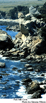
villages were right on the coast, including one just south of Stewart's Point called duwi maca el li ("where Coyote's sweat house is"). The village at Salt Point was qabe sihla wina -- "on flat rocks." Although today's park includes pine forest and upland habitats, it's still best known for its seaside rock formations. They're more varied and spectacular than the ones at, say Point Lobos near Monterey, but less well known because of the remote location.
Salt Point is a natural salt factory. Shallow basins on the sandstone shelves act as collectors for sea water splashed high on the rocks. The water gradually evaporates, leaving the basins with a coating of coarse sea salt which the Kashaya could scrape into baskets. The best salt basins are in an area of jumbled rocks about three-quarters of a mile north of the Gerstle Cove parking lot. No sign or trail marks this place -- you just have to hunt around. (Always keep an eye on the ocean when you're scrambling around the cliffs, so a high wave doesn't sweep you into the sea.)
Mussels, pried off the rocks at low tide, were an important food for the Kashaya, who knew when to collect them and when to leave them alone: during summer months, mussels and other shellfish can carry a toxin linked to summertime blooms of certain kinds of plankton. "The Kashaya at Salt Point and elsewhere along the coast acted as plant and seafood specialists for inland dwellers who came over the ridge to collect food," explains Caerleon Safford, interpretive specialist at Fort Ross State Historic Park, just down the road. "They helped inland visitors know when to eat the mussels and when to avoid them." Today's annual quarantine on summer mussel picking is an extension of the traditional knowledge the Kashaya passed on to visitors. When Russians maintained a settlement at Fort Ross from 1812-1839, near the Kashaya village of metini, they probably benefitted from the same kind of local expertise. The Kashaya also collected bull kelp that washed up after summer and autumn storms. The salty stalks, cut into strips and dried, were a handy cold remedy; you sucked on the kelp to soothe the throat and clear the sinuses. Sea palms, which the Kashaya call qaye, are dark green plants about a foot high that resemble miniature palm trees. They thrive on rocks in the tidal zone; the waves knock down the rubbery palms, which spring back up as soon as the wave recedes. The Kashaya chewed on the fresh qaye, bake it in ovens, or dried it in strips for use in the winter. (Kashaya Pomo Plants, recently reprinted in paperback by Berkeley's Heyday Books, gives a detailed run-down on which plants they used for food, dyes and medicines, etc.) | |||
|
After the Russians
left, other white settlers moved in, built ranch houses and mills, and shipped timber by schooner to San Francisco. Stone-cutters quarried blocks of stone from sandstone outcroppings and sent them to San Francisco, where they ended up as curbs for the streets of San Francisco. You can see the blocks they left behind, about a quarter mile north of Gerstle Cove.
By the 1870's there was a 15-room Salt Point hotel, general store and butcher shop and ambitious plans for a town of "Louisville," with a grid of streets covering the entire coastal terrace. The nearby timber gave out before Louisville could get off the ground, and today all that remains of the town is a street map with avenues named after the area's pioneers and mill-owners like Gerstle, Funcke, and the Duncan brothers. After this flirtation with development, Salt Point the town dwindled, reverted to its natural state. In 1968, as development was coming to nearby stretches of coast, the land became a state park. Today, hawks do most of the hunting in Salt Point; the sloping coastal terrace with its tangles of blackberry bushes and expanses of tough grass, is a great venue for Northern Harriers, Kestrels, Black Shoulder Kites, Red-tail hawks and other raptors. Hawks perch on the sandstone outcroppings -- look for them in silhouette against the sky -- and then glide out to nab startled field mice and unwary sparrows. | |||
|
 Salt Point
is on Highway One; from San Francisco, drive north on Highway 101; just north of Santa Rosa, take the River Rd. exit west to Highway One, then drive north about 20 miles. Salt Point has two campgrounds, Woodside and Gerstle. (The park's environmental campsite and another group camp near the shore were destroyed in a fire that swept the park three years ago.)
Salt Point
is on Highway One; from San Francisco, drive north on Highway 101; just north of Santa Rosa, take the River Rd. exit west to Highway One, then drive north about 20 miles. Salt Point has two campgrounds, Woodside and Gerstle. (The park's environmental campsite and another group camp near the shore were destroyed in a fire that swept the park three years ago.)
Camping reservations are handled through MISTIX, 800-444-7275. Day use is the standard $5 per car; the best place to start exploring is the Gerstle Cove parking lot. Gerstle Cove itself is a a natural reserve, off limits to fishing picking. But there's a launching place for floats and kayaks, and divers can observe the cove's marine life before paddling out into the ocean. Fisk Mill and Stump Beach, which form the northern part of Salt Point SP, are also favorite haunts for abalone divers and have separate parking lots. For more information call Salt Point at 847-3221, or State Parks' Russian River district office at 875-3483.
|
Albion Monitor February 8, 1997 (http://www.monitor.net/monitor)
All Rights Reserved.
Contact rights@monitor.net for permission to reproduce.

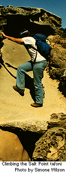 Aesthetically speaking, sandstone terrace is a gallery of weather-etched patterns called "tafoni." Wind and water pummel the soft cliffs, leaving them pitted with grains of salt. Wind and waves then go to work scouring out these tiny pockets until they became bigger pockets. Adjacent pits eventually merge and merge again, continually creating new patterns, so that the cliffs are scored with endless grooves, swirls, and arabesques. Tafoni occurs at other spots along the California coast, but Salt Point is more or less the world capital of tafoni.