River Townby Simone Wilson
|
 |
|
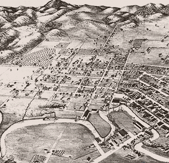
Petaluma
has seen a lot of ebb and flow in its 150-year history, mostly
because the town itself is a legacy of the sleepy estuary that wriggles up
here from San Francisco Bay. A walk along waterfront Petaluma uncovers the
origins of the town and reveals a neighborhood tourists don't usually see.
You wouldn't know it from the shopping centers and recent sprawl east of
Highway 101, but Petaluma is here because of the river.
When the Gold Rush hit California in 1849, a hundred thousand hungry miners spilled into San Francisco, and they all clamored for something to eat as soon as they landed. Food prices skyrocketed in the city by the bay; enterprising hunters, looking for deer and bear to send back to the city, sailed up this lazy river, and when they had gone upriver as far as a small boat would go, they got out and made camp. That camp became the nucleus of the town. Soon farmers and ranchers moved in, and warehouses and wharves sprang up along the bank between First Street and the river, with paddlewheelers chugging upstream at high tide to take produce and eggs to the markets of San Francisco. Petaluma had its own special boat specially designed with the smokestack in the stern instead of towards the bow, so heat from the engines wouldn't poach the eggs before they got down the river.
| |
|
Petaluma attracts tourists
today because of its stately Victorians and classic
downtown, a legacy of its prominent families like the NcNears and the
Wickershams.
But you'll get a feel for this other, riverside Petaluma by walking the
seven blocks along First Street, past numerous shops abuzz with activity.
Not shops as in boutiques: Walk First Street and you'll discover
metalshops, woodshops, and warehouses with hay bales stacked halfway to the
ceiling and a river out the backdoor.
Some of the docks are still there, a reminder of the time when transport meant barges and scows -- flat-bottomed boats able to navigate the shallow estuary that snakes up into Petaluma Valley from San Pablo Bay.
First Street starts just south of Petaluma's Great Mill and goes about seven blocks, ticking off the letters of the alphabet from C Street on until it deadends at Foundry Wharf on G Street. A spur of the railroad runs down the street; the rails vanish under the pavement at G Street. Foundry Wharf is a complex of offices for designers, architects and one-of-a-kind businesses like Salsa Cycles, where dozens of bike frames hang from the rafters. The complex is stylishly unpretentious, built of corrugated metal and landscaped with vines and poplars. Out back there's still a wharf of sorts -- a small dock with a few sailboats moored alongside. Across the river is a peninsula where cows graze on the dry stubble of late summer. From here the land across the river simply looks like the opposite bank, but it's really McNear Peninsula, a narrow, 17-acre strip between two arms of the river. Last December, the Sonoma County Open Space District agreed to trade the Lind family $184,000 for 10 acres of the peninsula for a future riverside park. But for now, the only users are a handful of drowsy cows and one Great Blue Heron, standing guard on the bank. | |
|
At 7 in the morning,
the neighborhood's nexus of activity is the Petaluma Coffee
Company, tucked into in one corner of Foundry Wharf. The space was once a
car repair shop, and retired mechanics who used to fix carburetors here
still come in for morning coffee.
This is a neighborhood that's been overlooked by entrepreneurs who turn everything into a cookie-cutter version of Carmel. Workers with sawdust on their jeans sip their java alongside men in pin-striped shirts, and in one corner a half-dozen designers from next door are huddled around some blueprints. To round out the diversity, a bold-looking man strides in decked out in calf-high, swashbuckler boots and maroon pantaloons. I recognize him as the actor who plays Francis Drake at the annual Renaissance Faire in Novato, and I picture Sir Francis abandoning his island of tea drinkers and coming back to California for a good cup of strong coffee. It's a typical misty morning in Petaluma, a remainder that fog was a cornetstone of early Petaluma's prosperity. Fog filters in from the coast during California's hot summers, providing a climate that's perfect for chicken ranching. (The birds have an unfortunate tendency to drop dead in extreme heat.) Two key inventions of the 1870's were perfected in Petaluma -- the modern incubator and a better brooder. They made large-scale chicken ranching profitable, and by 1910 Petaluma was shipping seven million eggs a year to San Francisco. In 1918 the town started billing itself as the Chicken Capital of the World. (Seniors remember that in the 40's and 50's the town called its semi-pro football the Leghorns.) If a town has enough chickens, they rate their own drug store, and Petaluma had The Chicken Pharmacy, featured in the February 1939 National Geographic, which dispensed 50,000 pullet pills a day.
| |
|
Just up the river
is Petaluma's downtown, with buildings dating from the
1880's. One of its showpieces is the two-part McNear Building, the northern
end built in 1886 and the southern half dating from 1911. (The 1906 quake
that demolished San Francisco and Santa Rosa spared Petaluma's now-historic
center.) Cream-yellow with red and black trim, the McNear Building takes up
most of the block; for an even better look at its gingerbready facade, walk
around to the Kentucky Street side.
The former Carnegie library is in the same block of Kentucky as the McNear Building. Once the Petaluma Free Library, it's now the town Museum. A block away on Petaluma Blvd., the banker Wickershams had their own building, built on the site of the first bank between San Francisco and Oregon. Constructed in 1910, it also housed an early silent movie theatre; today the downstairs is Graziano's Italian Restaurant. Across the street from McNear's is the Great Mill (corner of 2nd and D Streets), which started life as a waterfront warehouse. Later the McNears converted it to a mill, and today, after yet another facelift, it's a complex of shops and restaurants with the ones in back facing the river. In the 1980's the town spanned the river with a sturdy footbridge so tourists could stroll across to restaurants on the opposite bank. (I won't name the eateries, which can come and go with the tide.) To explore riverside Petaluma, take Highway 101 to Petaluma's Washington Street exit and go west. At Lakeville Highway turn left. You'll parallel the railroad tracks for a quarter mile, then turn right on D and go across the drawbridge. (You're crossing a river, remember?). At First Street, turn right and park near the Great Mill or turn left towards the Foundry Wharf. Park and explore. For more information call the Petaluma Visitor Program, 769-0429. |
Albion Monitor October 10, 1997 (http://www.monitor.net/monitor)
All Rights Reserved.
Contact rights@monitor.net for permission to reproduce.